Introduction
We have systematically analysed the demographic hotspots of India in the last several articles. We analysed the fall of Indic population in Uttar Pradesh and Uttarakhand [1], West Bengal [2], Assam [3], Kerala [4], Jammu and Kashmir [5], other assorted spots in the Hindi belt [6], and the tribal heartlands of central India [7]. Based on a talk delivered by Prof. Sarkar in August, we also analysed the India wide overview of the changes and implications thereof of the change in population, and the possible causes, solutions and non-solutions to the phenomenon [8]. In this article, based on a talk given by Prof. Sarkar in New York in October 2017, we shall analyse the age based religious demographics of India. In this article, we examine how the Indic population (by this we refer to practitioners of the religions that arose in the Indian subcontinent. This includes mainstream Hindus, Sikhs, Buddhists, Jains, and the practitioners of the various tribal faiths) is falling in many areas of India in the younger generation and how the population of the younger generation (0-4 age group) compares with the older generation (65-69) age group. We shall examine the regions where Indic population is collapsing. We shall take a quick look at the religious demographics of the young in big cities where Indic population is falling sharply. The change in demographics between the old and the young will indicate the trajectory of the future demography of India. We shall also examine the hotspots and examine the causes of the fall of the Indic population among the young. Finally, we shall also examine the rural and urban changes that are occurring in India in our bid to identify where the vulnerable spots are and the characteristics of the changes.
Background
Between 1872, when the first census was held and 2011, the latest census, the Indic population in united India has fallen from ~79% to 66% [8]. Further, it is of some importance to remark that the proportion of Indic population has fallen each and every decade since 1872. The graphs below will show the decadal changes between 1881 and 1941. Partition occurred when Indics had fallen to 73% of the total population. Both Muslims and Christians rose as a share of the population from 19.9% to 24.3% and 0.7% to 1.8% respectively between 1881 and 1941. In 1872, only Northwest Frontier Province, Jammu and Kashmir, Baluchistan and Sindh were Indic minority; both Bengal and Punjab were Indic majority.
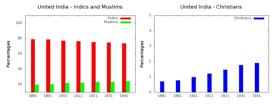 Further, it is important to mention that the rise of both Christianity and Islam and the fall of Indic religions has been very non-uniform. Due to the Partition, Hinduism more or less ceased to exist in West Pakistan and has greatly declined in East Pakistan. In West Pakistan, Indics have fallen from 19.7% in 1941 to ~2% in 2011 (The last census in Pakistan was in 1998 and consequently, the figures therein are extrapolations from that figure. A new census has been commissioned in 2017, but its results are not yet fully available) and in East Pakistan (now Bangladesh), Indics have fallen from 29% in 1941 to 8.9% in 2011 [8]. In the Indian Union, the total proportion of Indics has fallen from 87.2 to 83.2% between 1951 and 2011 [8]. Consequently, in this article, we shall attempt to discover where in the Indian Union the Indics have fallen in their population share and where their proportions are falling, especially in the younger generation. We shall examine initially, the demographic decline in the entire country, and examine the specifics in the areas of concern.
We shall examine the age related demographics, both urban and rural, of these areas. Apart from these, we shall examine the change of demographics in the major cities of concern in India.
Notation
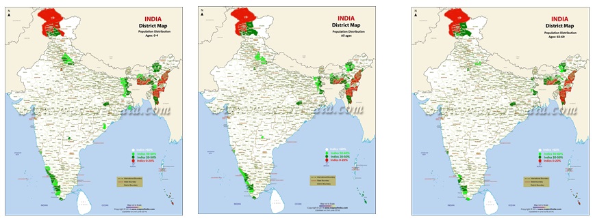
In our article, we have used the following notation for the colours in the maps. In maps where we have displayed the absolute share of the Indic population, we have used
- a) 60%+ Indic – white
- b) 50-60% Indic – light green
- c) 20-50% Indic – dark green
- d) <20% Indic – red.
In maps where we depict the changes of the population between the old (65-69) and the young (0-4) age groups, we have used the following colours.
- a) Positive change of Indics – saffron
- b) 0-5% fall of Indics – white
- c) 5-10% fall of Indics – light green
- d) 10-15% fall of Indics – green
- e) 15-20% fall of Indics – dark green
- f) 20%+ fall of Indics – red.
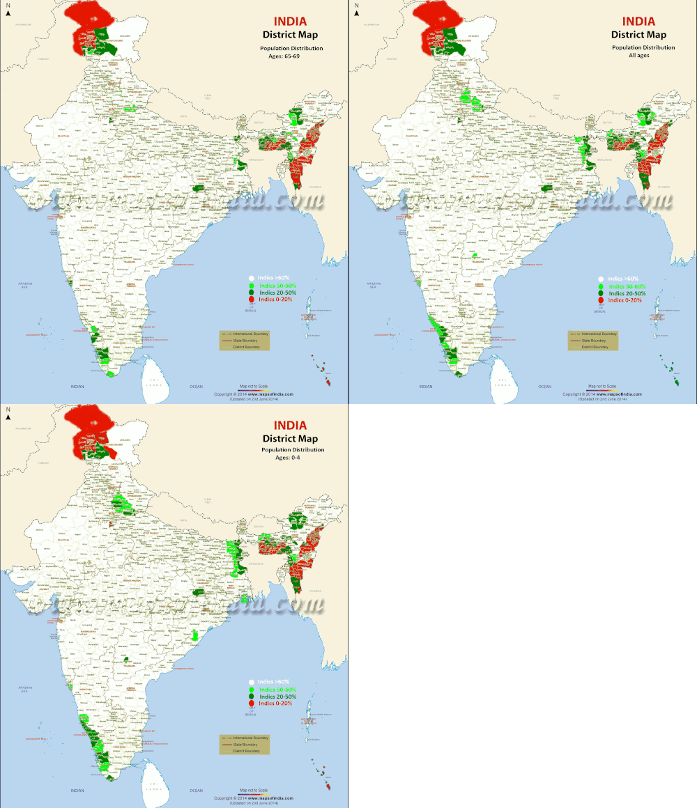 The above maps show that there are several areas where the Indic population is sharply falling between the old and the young. Indics have been totally wiped out in the North East and parts of Kashmir, so the change between the old and the young are minimal in these areas.
In addition to these maps that depict the absolute numbers of Indics in the 65-69 age group and 0-4 age groups in the various parts of India, we shall depict the change of the Indics across the country.
All these statistics have been computed at a district level in the various states in question using the 2011 census.
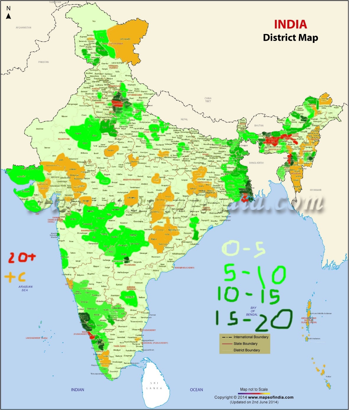 One point must be emphasised before we progress further. First, the positive change in parts of Gujarat, Rajasthan, Madhya Pradesh, Kerala, North East. Jharkhand and Chhattisgarh are mostly nominal. Only in Goa is there a slightly positive change and this is mainly due to the migration of Hindus from Maharashtra and Karnataka. In any case, nowhere is the positive change between the old and the young greater than 5%, as far as we can tell.
Another point is that on the Pakistan border, outside Jammu and Kashmir, Indic population is falling by more than 5% only in Kutch in Gujarat. In rural Kutch, the difference is >10%, with the Indic population falling from 81.87% in the old to 71.04 among the young. This is a serious fall and has implications for the border security.
From the above maps, we can see that the Indics are collapsing in seven regions principally.
- a) Western Uttar Pradesh, Southern Uttarakhand, Mewat and Shekhawati
- b) Bangladesh border
- c) Malabar, Canara and Coorg
- d) Arunachal Pradesh
- e) Jammu
- f) Tribal Odisha
- g) Manipur Valley
In addition to these regions, Indics have nearly vanished in the Meghalaya, Mizoram, Nagaland and Outer Manipur, that there are very few left to actually change in these regions. The positive changes that are shown in the various parts of Outer Manipur, Nagaland, Mizoram and Meghalaya are mostly cosmetic, given that the Indics have been nearly extirpated from these areas. The same holds true for the Nicobar Islands. The positive change in Ladakh is an artefact. The presence of a large number of servicemen (BSF, ITBP and army) skews the change in favour of Indics. However, the actual number of Buddhists in Ladakh is already in a decline [5] (and Buddhists are the most important set of Indics in Ladakh).
We shall examine each of the areas in detail, for both rural and urban changes.
Western Uttar Pradesh, Southern Uttarakhand, Mewat and Shekhawati
Western Uttar Pradesh
In the map shown, it is clear that the Indics are rapidly depleting in the Upper Doab, consisting of the districts of Saharanpur, Muzaffarnagar, Meerut, Baghpat, Hapur and Ghaziabad in Uttar Pradesh ( All the districts are as existed at the time of the census 2011. The statistics of newly created districts like Shamli should be read in the parent districts that existed in 2011). There is significant fall of Indics in all the districts of Rohilkhand, Aligarh and Mathura.
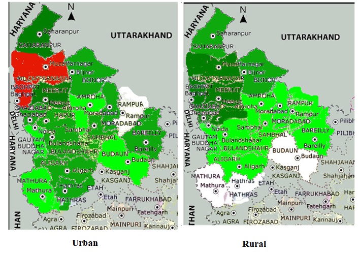 The collapse of the Indics in urban areas is most pronounced in the districts of Saharanpur, Meerut, Muzaffarnagar, and Baghpat, while the collapse of rural Indics is most pronounced in the districts of Meerut, Muzaffarnagar, Ghaziabad and Baghpat. It is interesting that while Ghaziabad and Baghpat are still strongly Hindu (73.85 and 71.7% respectively), the Indic population is rapidly depleting here. Urban areas of Rohilkhand and Aligarh, Bulandshahr, and Hathras are also rapidly depleting. Indeed, most of the urban areas of both Upper Doab and Rohilkhand are already Indic minority.
| District | Urban | Rural | ||||
| 65-69 | 0-4 | Change | 65-69 | 0-4 | Change | |
| Saharanpur | 59.84 | 40.23 | 19.61 | 69.20 | 54.45 | 14.75 |
| Muzaffarnagar | 62.27 | 40.91 | 21.26 | 71.88 | 52.27 | 19.71 |
| Meerut | 72.54 | 52.67 | 19.87 | 77.15 | 59.25 | 17.9 |
| Ghaziabad | 84.17 | 71.22 | 12.95 | 76.32 | 58.26 | 18.06 |
| Baghpat | 76.32 | 54.42 | 21.9 | 83.2 | 63.37 | 19.83 |
| Jyotiba Phule Nagar | 36.98 | 30.34 | 6.62 | 71.86 | 63.14 | 8.72 |
| Bijnor | 32.19 | 27.19 | 5 | 70.84 | 58.80 | 12.04 |
| Rampur | 33.22 | 29.18 | 4.04 | 58.31 | 53.09 | 5.22 |
| Moradabad | 50.24 | 40.18 | 10.06 | 61.26 | 52.09 | 9.17 |
| Bareilly | 58.93 | 48.41 | 10.52 | 75.55 | 70.27 | 5.28 |
| Aligarh | 67.12 | 57.06 | 10.06 | 91.64 | 86.47 | 5.17 |
| Bulandshahr | 68.29 | 55.47 | 12.82 | 86.9 | 82.9 | 4 |
From the above table, a few things are apparent.
- a) In the Upper Doab (Saharanpur, Muzaffarnagar, Meerut, Ghaziabad and Baghpat), Hindus are collapsing rapidly in both urban and rural areas, with the difference between the old and the young being as high as 21% and the lowest being 14.75% in rural Saharanpur. To say that the Hindu population in this region is collapsing is a massive understatement.
- b) In Rohilkhand (Jyotiba Phule Nagar, Bareilly, Bijnor, Moradabad and Rampur), Indic population in the urban areas is already reduced to a small minority (Jyotiba Phule Nagar, Bijnor and Rampur), or is collapsing sharply (Bareilly and Moradabad), with the difference being around 10% in areas which still have a significant urban population. The rural Indic population is also falling sharply in Bijnor (12.04%), Jyotiba Phule Nagar (8.72%) and Moradabad (9.07%). The rural population of Rampur is already at low levels (58.22%) and is falling by around 5% between the old and the young. Even in rural Bareilly, where the Indics are best off, Indics are losing around 5% of the population share between the old and the young.
- c) In the upper part of the Central Doab (Aligarh and Bulandshahr), the urban Indic population is falling sharply, by 10.06% in Aligarh and 12.82% in Bulandshahr. The rural populations are a little more stable, but even there, they are falling by 5.17 and 4% respectively between the old and the young.
Southern Uttarakhand
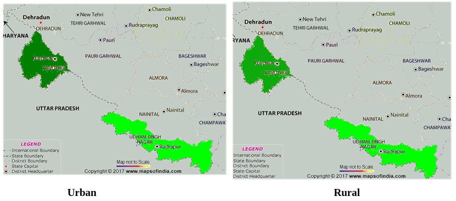 In the above map, it can be seen that Indics are rapidly depleting in the urban areas of Hardwar. Even rural Hardwar is badly affected, while there is significant erosion of Indic numbers in Shahid Udham Singh Nagar. In the table below, we have shown the actual numbers and estimate what it portends.
| District | Urban | Rural | ||||
| 65-69 | 0-4 | Change | 65-69 | 0-4 | Change | |
| Hardwar | 80.56 | 65.38 | 15.18 | 68.73 | 54.75 | 13.98 |
| Udham Singh Nagar | 71.96 | 62.05 | 9.91 | 86.98 | 78.89 | 8.09 |
| Dehra Dun | 92.97 | 84.15 | 8.82 | 89.63 | 82.45 | 7.18 |
| Naini Tal | 81.79 | 65.53 | 16.26 | 97.32 | 94.88 | 2.44 |
From the above table, it can be seen that the Indic population in Uttarakhand adjoining Upper Doab and Rohilkhand is fast depleting and in Hardwar, is actually collapsing. There is also a collapse of Indics in the urban areas of Naini Tal and a sharp depletion of Indics in the urban areas of Dehra Dun too. It would appear that the Upper Doab-Rohilkhand Muslim belt is progressing northwards into both Kumaon and Garhwal, especially in urban areas.
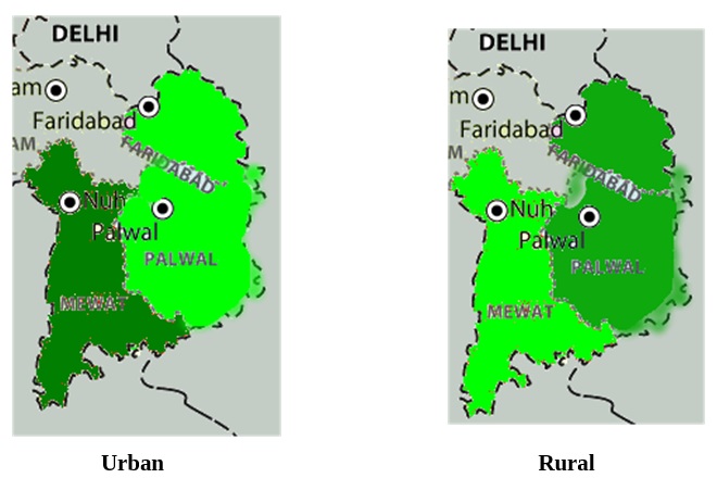
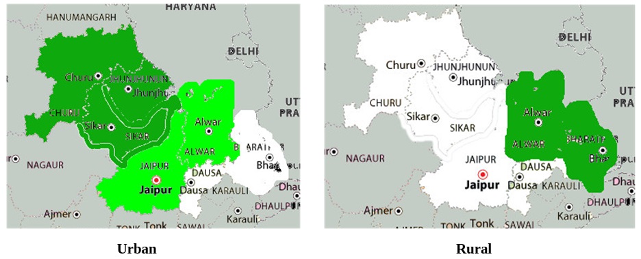
The two regions of Mewat and Shekhawati, while geographically adjacent, have not much in common when it comes to Muslim population. In Mewat (Mewat and Faridabad districts of Haryana and Bharatpur and Alwar districts of Rajasthan), the Indic population is collapsing in the rural areas since the bulk of the Meo Muslims are more rural than urban. Though, technically speaking, only a part of Faridabad, Alwar and Bharatpur districts are part of the cultural region of Mewat, but given that we do not have age based demographics of sub-districts, we have characterised Faridabad, Alwar and Bharatpur as belonging to Mewat. However, the high Muslim population of Shekhawati comes from the urban trader and other artisan classes that have settled there. There are hardly any Muslims in the rural areas of Shekhawati. However, given that they are adjacent, we have included them in the same group.
| District | Urban | Rural | ||||
| 65-69 | 0-4 | Change | 65-69 | 0-4 | Change | |
| Mewat | 64.94 | 45.06 | 19.86 | 20.43 | 11.19 | 9.24 |
| Faridabad | 94.68 | 89.02 | 5.62 | 88.36 | 78.34 | 10.08 |
| Alwar | 96.75 | 91 | 5.75 | 88.93 | 75.10 | 13.83 |
| Bharatpur | 97.38 | 95.27 | 2.11 | 87.42 | 74.96 | 12.46 |
| Churu | 74.19 | 61.81 | 12.38 | 96.27 | 94.56 | 1.71 |
| Jhunjhunu | 79.02 | 64.97 | 14.05 | 95.6 | 92.52 | 4.08 |
| Sikar | 72.66 | 58.02 | 14.64 | 95.71 | 93.34 | 2.38 |
The Indic population of rural Mewat district has been essentially wiped out so that there are almost no Indics left there. In urban Mewat district, the Indic population is rapidly falling, indicating that the Hindus are beginning to feel the pressure of the rural Meos in the urban areas too. In the other three districts of Mewat, the fall of Indic population is principally rural, indicating that the Hindus of rural Faridabad (including the present Palwal district), Alwar and Bharatpur are beginning to rapidly lose ground. Given that these districts were >85% Hindu in rural areas in the older generation, the fall is especially significant and portends ill for the Hindus of the region.
On the other hand, the fall of the Hindus in Shekhawati is mostly in the urban areas. In the rural areas, the Hindus are mostly >90% everywhere and are nowhere losing more than 4% of the population share. However, the Hindu fall in the urban areas of Shekhawati, ranging between 12 and 15% in all the three districts, is a matter of concern.
Bangladesh Border
Bihar
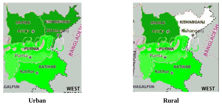 It is the north eastern corner of Bihar that has a demographic problem. This problem is spreading to the various areas of Mithila too, especially on the Nepal border, but for the time being, the most affected areas are in the North East of Bihar (called Seemanchal), comprising the districts of Kishanganj, Ararea, Purnea and Katihar. All these districts have been seriously affected in both the urban and rural areas. The table below will show the changes.
| District | Urban | Rural | ||||
| 65-69 | 0-4 | Change | 65-69 | 0-4 | Change | |
| Kishanganj | 61.51 | 48.39 | 12.12 | 33 | 28.01 | 4.99 |
| Ararea | 66.47 | 53.91 | 12.56 | 63.56 | 51.64 | 11.92 |
| Purnea | 81.3 | 71.42 | 9.88 | 63.5 | 56.11 | 7.39 |
| Katihar | 80.29 | 72.37 | 7.92 | 59.22 | 49.36 | 9.86 |
From the above map and table, it is clear that the Indics have been essentially wiped out in the rural Kishanganj, and are rapidly losing population share in urban Kishanganj. In Ararea, Purnea and Katihar, Indics are losing population sharply in both urban and rural areas by comparable amounts, but the Indic urban population is higher. This is characteristic of all the regions on the Bangladesh border, since most Bangladeshi illegals tend to prefer rural areas where they can gobble unoccupied and public lands for their private purposes.
Jharkhand
What is true for Seemanchal in Bihar is also true for the Indics of NE Jharkhand, in the old Santhal Paraganas. The influx of illegals from Bangladesh into the relatively unoccupied lands of Santhal Paraganas, especially adjoining Seemanchal and Murshidabad-Birbhum areas.
| Districts | Urban | Rural | ||||
| 65-69 | 0-4 | Change | 65-69 | 0-4 | Change | |
| Sahibganj | 74.54 | 60.65 | 13.89 | 61.01 | 51.64 | 9.37 |
| Pakur | 55.59 | 34.78 | 20.81 | 57.03 | 52.73 | 4.3 |
| Deoghar | 88.91 | 84.06 | 4.95 | 83 | 73.04 | 9.96 |
| Godda | 84.08 | 72.98 | 11.1 | 78.97 | 70.32 | 8.65 |
| Jamtara | 88.67 | 83.19 | 5.48 | 83.18 | 71.08 | 12.1 |
As may be observed from the above table, there are very serious collapses in the urban population of Sahibganj, Pakur and Godda, while there is sharp falls in the rural populations of Sahibganj Deoghar and Jamtara. These, we suspect, reflect the different industrialisations in the respective districts. In Pakur, the countryside is already heavily cultivated, and consequently, there are fewer lands for the illegal Bangladeshis to seize. However, in the more sparsely cultivated districts like Jamtara, Deoghar, Godda and Sahibganj, there is a considerable amount of unoccupied lands and consequently, Bangladeshis have found an easy home in the regions. In towns in Godda, Pakur and Sahibganj, the Bangladeshis have found good homes in various industries which tend to prefer Bangladeshis for the cheaper labour costs.
West Bengal
West Bengal, sharing a very long border with Bangladesh and without any laws that promote the welfare of the locals (as in Meghalaya or Mizoram), is suffering from a huge influx of illegal Bangladeshis. We shall examine the effects here.
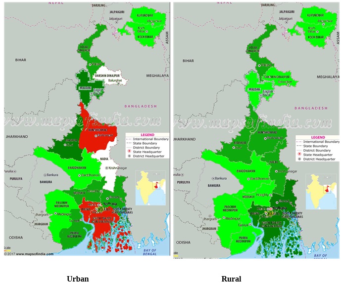 A look at the border districts in the above map will show that all the districts on the Bangladesh border are suffering a sharp decline in the number of Hindus. The situation is made worse by the fact that there is a significant Hindu migration (especially urban Hindus) to other states for economic reasons. In the table below, we display the changes in the affected districts.
| District | Urban | Rural | ||||
| 65-69 | 0-4 | Change | 65-69 | 0-4 | Change | |
| Koch Behar | 91.75 | 83.73 | 8.02 | 76.21 | 68.10 | 8.11 |
| Uttar Dinajpur | 91.90 | 81.49 | 10.41 | 49.23 | 36.86 | 12.37 |
| Dakshin Dinajpur | 98.5 | 97.75 | 0.75 | 73.19 | 65.9 | 7.29 |
| Maldah | 73.16 | 57.22 | 15.94 | 50.09 | 40.27 | 9.82 |
| Murshidabad | 59.23 | 29.11 | 30.12 | 35.94 | 25.04 | 10.9 |
| Nadia | 94.71 | 89.81 | 4.9 | 70.02 | 57.26 | 12.76 |
| Birbhum | 82.12 | 64.59 | 17.53 | 66.23 | 55.61 | 10.62 |
| Bardhaman | 89.77 | 80.42 | 9.35 | 78.27 | 71.94 | 6.33 |
| Hooghly | 91.18 | 81.33 | 9.85 | 85.31 | 78.88 | 6.43 |
| Howrah | 82.48 | 61.99 | 20.49 | 82.54 | 66.93 | 15.61 |
| Kolkata | 87.77 | 68.04 | 19.73 | |||
| N 24 Paraganas | 93.2 | 82.51 | 9.69 | 63.45 | 46.89 | 16.56 |
| S 24 Paraganas | 77.77 | 52.35 | 25.42 | 72.03 | 52.26 | 19.77 |
From the above table, we can see that there are seven districts where the fall of the Hindus is catastrophic. The two 24 Paragana districts are in the most serious danger, especially south 24 Paraganas, since it appears that this region is being heavily infiltrated by Bangladeshis. The same holds true for Howrah district as well, where the Indic population is collapsing (to put it mildly) in both the urban and rural areas. Apart from these districts, Uttar Dinajpur, Maldah and Murshidabad are all in serious danger, since the Indic population is low and collapsing. A combination of emigration of Hindus and immigration of illegal Bangladeshis is causing a huge demographic change in these districts. In the remaining districts, the fall of the Indics is serious, but not catastrophic.
Further, in West Bengal, Indics are rapidly depleting in both rural and urban areas in S 24 Paraganas, Howrah. Uttar Dinajpur, Birbhum and Murshidabad, in rural areas in N 24 Paraganas and Nadia, and in urban areas in Maldah. Ground level reports indicate that the two 24 Paraganas districts, Howrah, and Nadia are dens of illegal Bangladeshi immigrants.
Assam
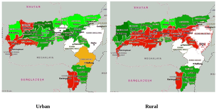 A look at the above map shows that the Indics are collapsing in Assam, both in urban and rural areas, with rural areas being the most seriously affected since the Bangladeshis tend to prefer the rural areas for settlements. Only Dima Hasao, with its own laws on land ownership, is showing a positive change in the number of Indics in the urban areas.
| District | Urban | Rural | ||||
| 65-69 | 0-4 | Change | 65-69 | 0-4 | Change | |
| Dhubri | 68.98 | 45.39 | 23.59 | 23.26 | 9.75 | 13.51 |
| Kokrajhar | 92.74 | 84.18 | 8.56 | 65.76 | 50.08 | 15.68 |
| Goalpara | 52.71 | 29.43 | 23.28 | 45 | 22.85 | 22.15 |
| Barpeta | 89.31 | 74.47 | 14.84 | 37.03 | 14.17 | 22.86 |
| Bongaigaon | 91.17 | 75.82 | 15.65 | 57.52 | 28.86 | 28.66 |
| Kamrup | 84.6 | 74.31 | 10.29 | 65.08 | 42.41 | 22.67 |
| Nalbari | 89.58 | 82.63 | 6.95 | 72.38 | 47.06 | 25.32 |
| Chirang | 87.77 | 63.29 | 24.58 | 73.3 | 59.13 | 14.17 |
| Baksa | 80.44 | 62.35 | 18.09 | 87.67 | 76.92 | 10.75 |
| Darrang | 83.04 | 78.42 | 4.62 | 47.28 | 19.74 | 27.56 |
| Nagaon | 82.94 | 62.25 | 20.69 | 51.24 | 28.05 | 23.19 |
| Morigaon | 76.09 | 59.96 | 16.13 | 55.27 | 34 | 21.27 |
| Sonitpur | 90.8 | 80.85 | 9.95 | 79.21 | 65.68 | 13.53 |
| Karimganj | 81 | 53.41 | 27.59 | 52.24 | 30.26 | 21.98 |
| Hailakandi | 84.95 | 60.68 | 24.27 | 42.8 | 30.3 | 12.5 |
| Cachar | 84.52 | 70.69 | 13.83 | 62.78 | 50.21 | 12.57 |
| Lakhimpur | 81.25 | 67.27 | 13.98 | 84.74 | 70.16 | 14.58 |
A look at the above table will show that the Indic populations have collapsed totally in lower Assam (including the Bodo districts, for Kokrajhar, Baksa and Chirang are also showing serious Indic collapse). The same can be said for the Barak valley. The Bangladeshi infiltration that was more a rural phenomenon is now spreading to large numbers of urban areas and Indics are collapsing in both rural and urban districts. More importantly, districts of Upper Assam like Lakhimpur and Sonitpur are showing serious collapse of Indics. This indicates that Upper Assam is also living on borrowed time.
Tripura
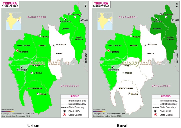 From the above maps, it is clear that the districts on the Bangladesh borders of Tripura are also showing serious Indic fall, especially in the rural areas. Bangladesh is spreading all along the borders, from Bihar to Tripura.
| District | Urban | Rural | ||||
| 65-69 | 0-4 | Change | 65-69 | 0-4 | Change | |
| North | 96.61 | 90.69 | 6.22 | 80.92 | 70.86 | 10.06 |
| West | 88 | 81.02 | 6.98 | 97.03 | 91.95 | 5.08 |
North Tripura on the borders of Assam is beginning to show serious fall. While the fall is not yet huge compared to neighbouring Assam, it shows every sign of becoming serious.
Jammu
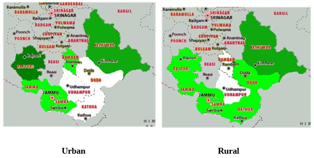 From the above maps, it should be apparent that Indics are losing population share in both the hills and the plains. In the hills, Rajouri is rapidly losing Indics in both urban and rural areas, while in the plains, Kishtwar and Doda, there is a steady erosion of Indics in especially rural areas. Only Udhampur is more stable. The table below shows the changes
| District | Urban | Rural | ||||
| 65-69 | 0-4 | Change | 65-69 | 0-4 | Change | |
| Jammu | 95.14 | 88.44 | 6.7 | 94.93 | 89.26 | 5.67 |
| Kathua | 96.43 | 93.70 | 2.73 | 91.02 | 84.74 | 6.28 |
| Rajouri | 66.67 | 49.35 | 17.32 | 36.58 | 26.86 | 9.72 |
| Reasi | 89.67 | 82.21 | 7.46 | 50.76 | 38.79 | 11.97 |
| Ramban | 42.71 | 35.78 | 6.93 | 26.43 | 25.04 | 1.39 |
| Doda | 26.78 | 26.75 | 0.03 | 49.87 | 42.38 | 7.49 |
| Kishtwar | 25.6 | 23.29 | 2.31 | 48.43 | 35.81 | 12.62 |
The sharp collapse of Indics in Rajouri, given their already small population is a matter of serious concern. The significant fall of Indics in the rural areas of Jammu and Kathua is also a matter of concern given how high their populations were, to start with. The Indic population in the rural areas of Kishtwar and Doda is also rapidly depleting, as may be seen from the table.
A word about the Kashmir valley and Ladakh are appropriate. Ladakh has a large number of servicemen (military and paramilitary); consequently, it is hard to estimate the fall of the Indics since these are not enumerated separately. However, the fall in the absolute number of Buddhists shows that this region is also doing badly, with a very low total fertility rate. As for the Kashmir Valley, the Indics there have practically been exterminated, so computing the difference is pointless, since there are few left to be counted, in any age group.
Malabar, Coorg and Canara
This region has seen one of the most rapid depletions of Hindus in recent years. A combination of emigration of Hindus to newer opportunities, low fertility among Hindus and a high fertility among Muslims have combined to bring Hindu populations to historic lows.
Malabar
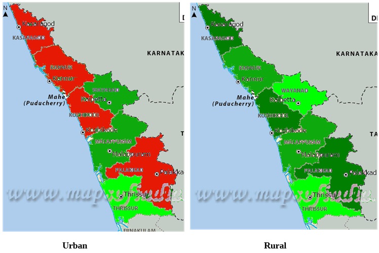 A look at the map above tells the story of disastrous Indic collapse in the region. Indics are below 60% in all districts except Palakkad and are minorities in two districts (Malappuram and Wayanad) already. We examine the changes in the table below.
| District | Urban | Rural | ||||
| 65-69 | 0-4 | Change | 65-69 | 0-4 | Change | |
| Kasaragod | 61.65 | 37.80 | 23.85 | 66.16 | 49.21 | 16.95 |
| Kannur | 73.51 | 50.49 | 23.02 | 55.67 | 45.15 | 10.52 |
| Wayanad | 55.22 | 42.9 | 12.32 | 52.52 | 45.69 | 6.83 |
| Kozhikode | 69.29 | 47.37 | 21.92 | 55.07 | 37.06 | 18.01 |
| Malappuram | 33.78 | 19.67 | 14.21 | 33.09 | 20.85 | 12.24 |
| Palakkad | 75.65 | 53.94 | 19.71 | 74.73 | 57.5 | 17.23 |
| Thrissur | 60.28 | 51.64 | 8.64 | 62.9 | 54.69 | 8.21 |
High literacy and education leading to low fertility, lack of economic opportunity coupled with a cultural predisposition to emigration for economic prospects, especially in the northern districts, along with a high Muslim population with high fertility has led to a collapse of the Indic population in the northern Malabar. The collapse is in both urban and rural areas, but with urban areas predominating. In Malappuram, Palakkad, Kozhikode, Kannur and Kasaragod, Indic population is collapsing catastrophically, while even in Thrissur and Wayanad, the fall in Indic populations is very serious indeed.
Canara and Coorg
The same tale repeats in the districts of Coorg and Dakshin Kannada in Karnataka, which is just across the border for Malabar. Influx of Muslims, high fertility among Muslims, emigration of Indics for economic opportunities, along with a cultural predisposition to emigrate to economic opportunities, and low fertility among Indics have had a disastrous effect on the Indics of the region.
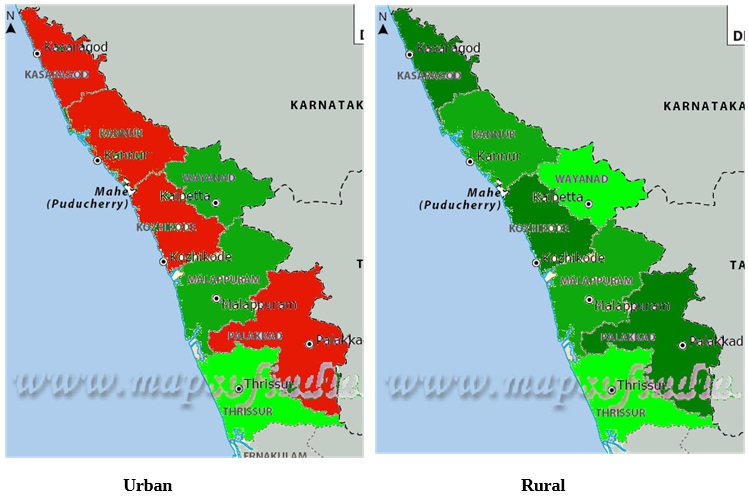 The twin districts of Coorg and Dakshin Kannada (South Canara) are the suffering from the same fate as the adjoining districts of Kerala, both in urban and rural districts. The exact fall has been captured in the table shown below.
| District | Urban | Rural | ||||
| 65-69 | 0-4 | Change | 65-69 | 0-4 | Change | |
| Coorg | 75.98 | 64.10 | 11.88 | 87.28 | 77.52 | 9.76 |
| Dakshin Kannada | 69.17 | 53.13 | 16.04 | 78.72 | 64.61 | 14.11 |
Manipur Valley
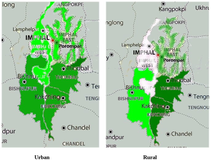 In Manipur valley, we observe a different pattern to the fall of Indic demography. In Manipur, the outer Manipur is almost completely Christian, with little in the way of economy. What economy exists is centred in the Manipur valley, dominated by the Hindu (and Sanamahi) Meiteis. This has, consequently, triggered an influx of working age Christians into the Manipur valley, leading to a fall of Indics in the younger generation. The exact fall is characterised in the table below
| District | Urban | Rural | ||||
| 65-69 | 0-4 | Change | 65-69 | 0-4 | Change | |
| Bishnupur | 93.05 | 82.89 | 11.06 | 95.58 | 87.66 | 7.92 |
| Thoubal | 85.99 | 71.40 | 14.59 | 81.11 | 65.94 | 15.17 |
| Imphal East | 84.97 | 76.12 | 8.85 | 81.44 | 69.89 | 11.55 |
| Imphal West | 94.10 | 86.68 | 7.42 | 95.48 | 91.49 | 3.99 |
Arunachal Pradesh
In Arunachal Pradesh, we come to yet another kind of change. In Arunachal Pradesh, most of those targeted for conversion are the younger people – those in the working age. The older generation is not converted and generally dies away, without being converted. This phenomenon was first observed in Nagaland, where the older generation often died out without converting, leaving only the converted younger generation to remain in Christianity. The same phenomenon is being observed now in parts of western Arunachal Pradesh. Most changes in Arunachal Pradesh have occurred around Itanagar and its adjacent districts or in the extreme east, where Indics are wiped out.
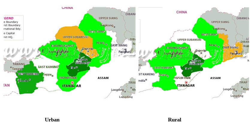 The actual differences have been noted in the table below
| District | Urban | Rural | ||||
| 65-69 | 0-4 | Change | 65-69 | 0-4 | Change | |
| West Kameng | 97.03 | 85.12 | 11.91 | 89.57 | 85.09 | 4.48 |
| East Kameng | 55.17 | 51.75 | 3.42 | 53.42 | 48.13 | 5.29 |
| Papum Pare | 65.65 | 56.42 | 9.23 | 24.71 | 24.61 | 0.1 |
| Kurung Kumey | 48.83 | 38.98 | 9.85 | |||
| Lower Subansiri | 63.53 | 63.13 | 0.4 | 64.63 | 45.4 | 19.23 |
| West Siang | 84.95 | 75.70 | 9.25 | 73.54 | 66.71 | 6.83 |
Tribal South Odisha
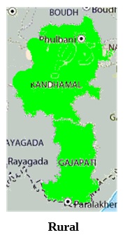 The phenomenon described above has also been observed in tribal south Odisha. It is shown in the table below, in the rural areas of south Odisha
| District | Rural | ||
| 65-69 | 0-4 | Change | |
| Kandhamal | 81.85 | 73.82 | 8.03 |
| Gajapati | 63.74 | 53.84 | 9.9 |
Since it is tribals of the working age that convert, the disparity emerges in these regions.
Major cities
In the last section, we shall examine how the major cities of India are faring. We have chosen the 50 major cities of India. These are rapidly growing cities with migration playing a major role in them. Consequently, we shall not evaluate the difference between the old and the young, but we shall highlight how the changes have occurred between 1991 and 2011 census in terms of the total Indic population share and how the young (0-4) compare with the overall population figures.
It has been claimed by many that the Hindus are migrating to the cities from the smaller urban areas, to account for the falling Hindu population proportions of small towns and semi-urban areas. In this article, we investigate if this is indeed true. If the Hindus are migrating in huge numbers to the metros, then we should see the rise of the Hindus in the younger generations, especially in the working and child age groups, since young couples are more likely to have children.
We chose the fifty biggest cities of India, all with population of greater than or extremely close to a million. In twelve of the fifty cities, we found that the proportion of the Indics (Hindus, Buddhists, Jains, and Sikhs) was under 80%. The twelve cities are Mumbai (corporation area), Hyderabad, Kolkata, Lucknow, Thane, Bhopal, Meerut, Varanasi, Aurangabad, Srinagar, Allahabad, Ranchi and Thiruvananthapuram. In these twelve cities, we have examined the change of the demographics of the Indics. In summary, we shall also take a quick look at the others, particularly the top twenty to which the migration has been pronounced.
| Cities | 1991 Indic Pop. | 2001 Indic Pop. | 2011 Indic Pop. | 0-4 Indics in 2011 |
| Mumbai | 78.73 | 77.68 | 75.83 | 69.79 |
| Hyderabad | 58.32 | 56.18 | 52.75 | 46.45 |
| Kolkata | 81.4 | 78.57 | 77.42 | 68.04 |
| Lucknow | 75.00 | 73.81 | 72.84 | 68.56 |
| Bhopal | 70.77 | 72.30 | 72.22 | 70.01 |
| Meerut | 65.42 | 63.44 | 63.88 | 54.68 |
| Varanasi | 71.01 | 68.58 | 70.49 | 66.16 |
| Srinagar | 11.56[1] | 2.34[2] | 1.82 | 1.43[3] |
| Aurangabad | 69.73 | 69.95 | 68.09 | 63.87 |
| Allahabad | 77.69 | 78.97 | 76.78 | 73.77 |
| Ranchi | 74.89 | 74.29 | 74.71 | 73.42 |
| Thiruvananthapuram | 72.45 | 71.17 | 68.6 | 62.53 |
- The population percentage of Srinagar is taken from 1981, since there was no census in Jammu and Kashmir in 1991.
- Includes Badami Bagh, which is counted separately in this census.
- This is computed based on an estimate of the actual number of Indic civilians in Srinagar, leaving out the servicemen. However, since the census does not specify them separately, we have no means of actually computing the number.
Given the high migration rates to these cities, the population figures are not very stable and tend to vary a bit across census. Nevertheless, the general trend is clear and with the solitary exception of Bhopal, the Indic population percentages have come down in all the cities, compared to 1991. The population of the Indics is coming down even in the major cities, despite a high rate of Hindu migration to these cities. It is becoming clear that, even in the major cities, the Indics are losing population share wherever there was already a significant minority population.
Further, it is clear that the Indics in the 0-4 age group are also losing population share rapidly in most areas, despite the migration of a large number of working age Indics who are likely to have more children. The statistics of Mumbai metropolitan area hide a few facts. Mumbai urban area comprises of two separate districts (Mumbai and Mumbai Suburban). In Mumbai district, the Indics are down to 71.92%, with the 0-4 age group having only 65.11% Indics, with only 55.59% of them being Hindus. The second worrisome statistic is that there of the remaining 9.52% Indics, 4.27% comes from Buddhists, among whom there is a significant number of converts to Christianity, but remain Buddhists on paper. Consequently, Mumbai district, which has a total population of 30 lakhs (roughly two thirds the population of Kolkata), is in significant danger of being only around 60% Indic already, with the Indic population falling by 2-3% every decade. Kolkata also has a sharply lower rate of 0-4 population compared to the total population (9.5% lower), but this is mostly due to the high fertility rates of the illegal Bangladeshi immigrants in the city. Meerut has the worst statistics and is likely to fall below the 50% Indic mark in the 0-4 age group in next couple of census.
References
All the data is based on the census reports of 2011. The census figures of 2001 in the tables on major cities is based on the 2001 census report. The figures for 1991 census were taken from AP Joshi, MD Srinivas and JK Bajaj, “Religious Demography of India”
[1] Shanmukh, Saswati Sarkar, and Dikgaj, “Western Uttar Pradesh and Southern Uttarakhand: Muslim Majority by 2061?” http://www.dailyo.in/politics/population-muslims-muzaffarnagar-
uttarakhand-shamli-western-uttar-pradesh-hindus-sikh-demography/story/1/10631.html
[2] Shanmukh, Saswati Sarkar and Dikgaj, “A Demographic Warning for West Bengal” https://www.myind.net/Home/viewArticle/demographic-warning-west-bengal
[3] Shanmukh, Saswati Sarkar, Dikgaj and Aparna, “Will Assam be Muslim Majority in the next 40 Years” https://indiafacts.org/will-assam-muslim-majority-next-40-years/
[4] Shanmukh, Saswati Sarkar, Dikgaj and Aparna, “Kerala and South Tamizh Nadu: A Case of Hindu Fade Out” https://indiafacts.org/kerala-south-tamil-nadu-case-hindu-fade/
[5] Shanmukh, TrueIndology, Aparna, Saswati Sarkar and Dikgaj, “Demographic Expansion of Kashmir and Shrinking of Jammu and Ladakh” https://www.myind.net/demographic-expansion-kashmir-and-shrinking-jammu-and-ladakh#.V3UOVSF0xwc.twitter
[6] Shanmukh, Aparna, TrueIndology, Arihant, Saswati Sarkar and Dikgaj, “Hotspots in the Hindi Belt” https://www.pgurus.com/hotspots-hindi-belt-part-1-northern-arc/%C2%A0 https://www.pgurus.com/hindu-population-shrinking-part-2-hotspots-series/%C2%A0 https://www.pgurus.com/computed-hindu-muslim-christian-growth-part-3-hotspots-series/
[7] Shanmukh, Aparna, Saswati Sarkar and Dikgaj, “The Rapid Christianisation of Tribal Regions of Central India” https://indiafacts.org/rapid-christianization-tribal-regions-central-india-story-numbers/ https://indiafacts.org/tribal-regions-central-india-rapidly-christianized/
[8] Shanmukh, Kirtivardhan Dave, Saswati Sarkar and Dikgaj, “The Endangered Indics of India” https://myind.net/Home/viewArticle/endangered-indics-in-india-an-overview
Featured Image: Wikipedia

